


Voting Districts not defined, Houghton County, Michigan
About
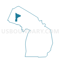
Outline

Summary
| Unique Area Identifier | 596797 |
| Name | Voting Districts not defined |
| County | Houghton County |
| State | Michigan |
| Area (square miles) | 459.60 |
| Land Area (square miles) | 0.00 |
| Water Area (square miles) | 459.60 |
| % of Land Area | 0.00 |
| % of Water Area | 100.00 |
| Latitude of the Internal Point | 47.34260300 |
| Longtitude of the Internal Point | -88.72258480 |
Maps


Graphs
Select a template below for downloading or customizing gragh for Voting Districts not defined, Houghton County, Michigan


Neighbors
Neighoring Voting District (by Name) Neighboring Voting District on the Map
- Voting District 0130534000002, Baraga County, MI
- Voting District 0611260000001, Houghton County, MI
- Voting District 0611492000001, Houghton County, MI
- Voting District 0613632000001, Houghton County, MI
- Voting District 0617184000001, Houghton County, MI
- Voting District 0617620000001, Houghton County, MI
- Voting District 0617620000002, Houghton County, MI
- Voting District 0618012000002, Houghton County, MI
- Voting District 0837322000001, Keweenaw County, MI
- Voting District 1310946000002, Ontonagon County, MI
- Voting Districts not defined, Ontonagon County, MI
- Voting Districts not defined, Keweenaw County, MI
- Voting Districts not defined, Marquette County, MI
- Voting Districts not defined, Baraga County, MI
Top 10 Neighboring County Subdivision (by Population) Neighboring County Subdivision on the Map
- Calumet charter township, Houghton County, MI (6,489)
- Baraga township, Baraga County, MI (3,815)
- Torch Lake township, Houghton County, MI (1,880)
- Schoolcraft township, Houghton County, MI (1,839)
- Chassell township, Houghton County, MI (1,812)
- Stanton township, Houghton County, MI (1,419)
- Hancock township, Houghton County, MI (461)
- Bohemia township, Ontonagon County, MI (82)
- Sherman township, Keweenaw County, MI (67)
- County subdivisions not defined, Keweenaw County, MI (0)
Top 10 Neighboring Elementary School District (by Population) Neighboring Elementary School District on the Map
- Stanton Township Public Schools, MI (1,421)
- Powell Township Schools, MI (894)
- Arvon Township School District, MI (450)
Top 10 Neighboring Unified School District (by Population) Neighboring Unified School District on the Map
- Calumet Public Schools, MI (8,473)
- Hancock Public Schools, MI (6,831)
- L'Anse Area Schools, MI (4,992)
- Baraga Area Schools, MI (4,089)
- Lake Linden-Hubbell School District, MI (3,730)
- Ontonagon Area Schools, MI (3,632)
- Adams Township School District, MI (2,883)
- Chassell Township School District, MI (1,812)
Top 10 Neighboring State Legislative District Lower Chamber (by Population) Neighboring State Legislative District Lower Chamber on the Map
Top 10 Neighboring State Legislative District Upper Chamber (by Population) Neighboring State Legislative District Upper Chamber on the Map
Top 10 Neighboring 111th Congressional District (by Population) Neighboring 111th Congressional District on the Map
Top 10 Neighboring Census Tract (by Population) Neighboring Census Tract on the Map
- Census Tract 2, Baraga County, MI (4,558)
- Census Tract 7, Houghton County, MI (3,224)
- Census Tract 10, Houghton County, MI (3,042)
- Census Tract 1, Houghton County, MI (2,611)
- Census Tract 1, Keweenaw County, MI (2,156)
- Census Tract 9701, Ontonagon County, MI (1,935)
- Census Tract 9900, Marquette County, MI (0)
- Census Tract 9900, Houghton County, MI (0)
- Census Tract 9901, Ontonagon County, MI (0)
- Census Tract 9901, Keweenaw County, MI (0)
Top 10 Neighboring 5-Digit ZIP Code Tabulation Area (by Population) Neighboring 5-Digit ZIP Code Tabulation Area on the Map
- 49931, MI (9,630)
- 49913, MI (7,248)
- 49930, MI (6,987)
- 49916, MI (2,765)
- 49945, MI (2,621)
- 49905, MI (2,005)
- 49958, MI (1,270)
- 49965, MI (440)
- 49805, MI (336)